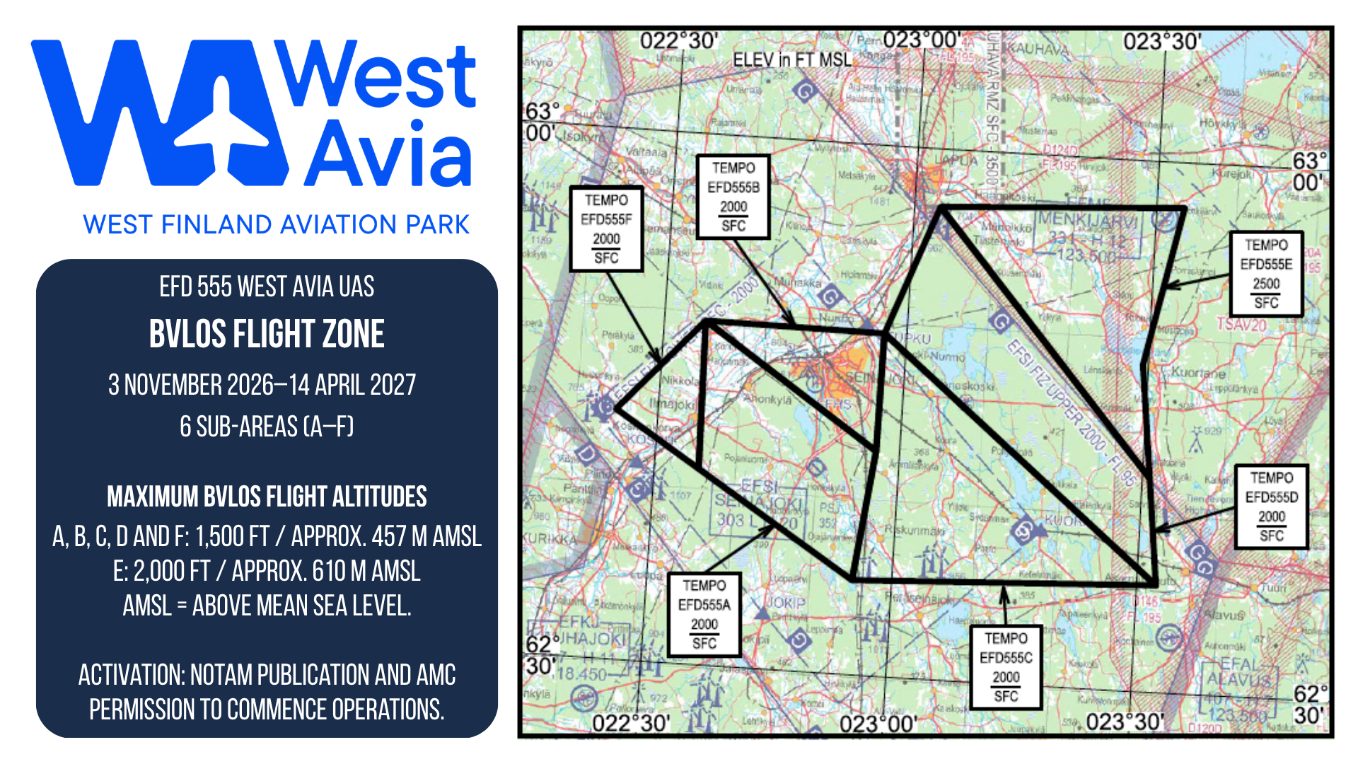
A temporary danger area around Seinäjoki Airport will strengthen West Avia’s role as an environment for drone development and trials. The area will support the testing of longer flight routes, new services and drone technology.
On 13 October 2026, the Finnish Transport and Communications Agency Traficom approved the establishment of the temporary EFD555 WEST AVIA UAS danger area following an application by the Rengonharju Foundation. The area will be valid from 3 November 2026 to 14 April 2027.
The airspace arrangement supports beyond visual line of sight (BVLOS) operations by unmanned aircraft, commonly known as drones. BVLOS means flying beyond the remote pilot’s direct visual line of sight, allowing longer routes and larger operating areas than flights where the drone must remain continuously in sight.
Temporary EFD555 WEST AVIA UAS danger area. Valid from 3 November 2026 to 14 April 2027.
Opportunities for businesses, research and training
The extensive operating area opens up opportunities to develop and trial drone applications in a real-world environment. Potential uses include mapping and inspection flights, agricultural and forestry applications, cargo delivery trials, and testing drone command and control links, navigation and performance.
The winter operating period also provides an opportunity to plan trials assessing how aircraft and systems perform in Finnish winter conditions.
For West Avia, the airspace arrangement is an important step in developing Seinäjoki Airport as a location for unmanned aviation. It supports cooperation between businesses, research organisations and training providers, as well as the development of new services.
Six sub-areas activated as needed
EFD555 WEST AVIA UAS consists of six sub-areas that can be activated to meet the needs of planned operations. The area extends well beyond the immediate surroundings of Seinäjoki Airport.
The maximum BVLOS flight altitude in five of the sub-areas is 1,500 feet, approximately 457 metres above mean sea level. In one sub-area, the maximum is 2,000 feet, approximately 610 metres above mean sea level. Flight planning must account for terrain elevation and all other applicable operating conditions.
Coordinated operations
The area will be activated for planned flights in coordination with Finland’s Airspace Management Cell (AMC). Operations require advance notification, the area’s activation will be communicated to airspace users, and flights may begin only once AMC has granted permission to commence operations.
The danger area decision forms part of the framework for operations. Flights and access to the area are also governed by the conditions of West Avia’s permissive UAS geographical zone and other applicable requirements. Trials by individual businesses will be planned within these conditions.
Businesses, research organisations and training providers interested in using the area are welcome to contact West Avia to explore opportunities for trials and collaboration.


Elisabet Kivimäki
Yrityskehityspäällikkö, Into Seinäjoki




Leave a Reply